ABC News
 ABC NewsBy MAX GOLEMBO, ABC News
(NEW YORK) — From California to New Jersey, heat will be the story for the holiday weekend forecast.
For example, it’s been the hottest start of the summer since 2005 in Albany, New York, where it has already had seven days of 90-plus degrees.
Also, the heat reached most of the northern reaches of the lower 48 states Thursday with Duluth, Minnesota, breaking a record high temperature with 93 degrees.
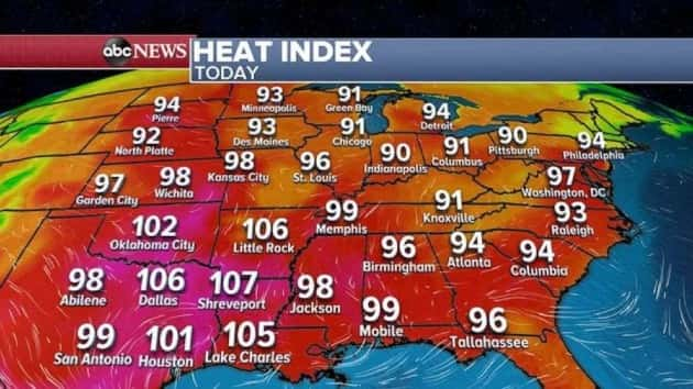
More heat and humidity east of the Rockies is in the forecast Friday, with most areas feeling like its 90 to 100 degrees. Some areas will feel closer to 110 degrees in the South-central states.
A heat advisory has been issued from Minneapolis all the way down to Shreveport, Louisiana, Friday.
Over the holiday weekend, the heat will hang out for most of the East Coast, and then spread into the West as well, with 110 degrees possible in southern California.
The only relatively cooler areas will be in New England and in the Pacific Northwest, where temps will be mostly in the 70s.
Strong to severe storms from the Plains to the Northeast are worth monitoring this weekend.
Already more than 150 damaging storms reports have been observed from Colorado to Maine Thursday, with five reported tornadoes in Colorado and Nebraska. No damage was reported with these tornadoes.
As the cold front moves through the Northeast, strong to severe storms are possible from Vermont down to New Jersey, where damaging winds and some hail will be the biggest threat.
More severe storms are expected in the Plains from western Montana and Wyoming to the Dakotas, where damaging winds and large hail will be the biggest threat.
Last but not least, a stationary front will continue to sit across the South and produce more storms from Oklahoma to Florida. The biggest threat in the South will be heavy rain that could produce flash flooding, where some areas could see more than 4 inches of rain.
Copyright © 2020, ABC Audio. All rights reserved.